
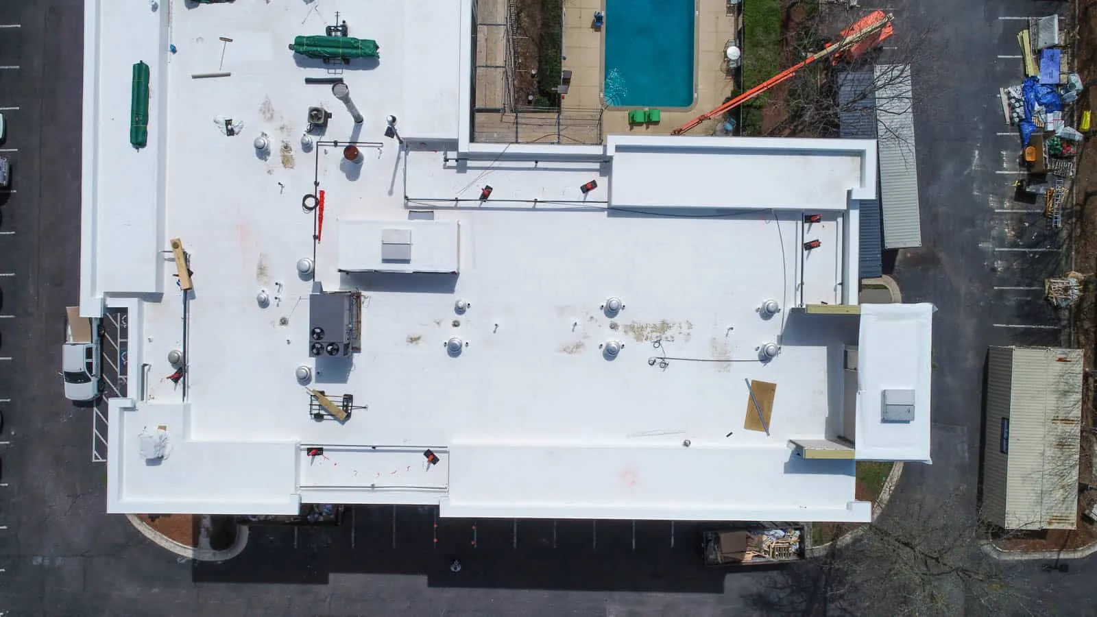
Drone Roof Inspection in Denton, TX
An overhead image can show the roof layout before anyone crosses it. In Denton, TX, drone imaging may help document broad roof areas, inaccessible sections, or a post-weather condition where flight is permitted. The image is not a diagnosis. We set the inspection question, confirm site permissions, and pair useful views with the roof plan. A hands-on inspection remains necessary for seams, flashings, and details that require close review.
Choose the Question First
Use aerial imaging when the team needs an overview, a roof-area map, or a consistent set of visible surface photographs. It can help document debris distribution, obvious openings, ponding patterns, or a large roof's relationship to rooftop equipment. It cannot see beneath the membrane, measure attachment, or establish whether a surface discoloration is moisture. The plan should state which question the flight is meant to support.
Record roof zones, image direction, date, weather, and visible obstructions. If the building is active, identify staff, equipment, and pedestrian areas below the flight path. A roof near Westpark may have industrial operations, while a downtown property may have tighter public-space constraints. These are planning cues, not assumptions about a particular site. Confirm the property contact and applicable flight permissions before launch.
Clear Permissions and Safe Conditions
Before flight, confirm owner authorization, airspace restrictions, local rules, weather, wind, visibility, and safe takeoff and landing points. The pilot follows applicable FAA requirements. Building operations may require escorts, time windows, or a spotter. Do not fly over people or interfere with emergency response. If conditions prevent a safe and compliant flight, reschedule or use another inspection method.
Document the flight boundary and any section not captured. Nearby corridors such as Loop 288 and US 380 can have active transportation work, but an aerial inspection should not assume construction zones are open or safe. A site contact identifies property boundaries and restricted areas. The image set should be retained with the inspection date and roof plan so later viewers know what they are seeing.
Read the Image as Evidence
Review images for visible punctures, lifted edges, debris, standing water, displaced covers, and changes around curbs. Compare angles and adjoining roof zones. An overhead shadow can resemble a defect; reflections can hide a seam. Mark each suspect point on the plan and confirm it from the roof where access is allowed. The report should label findings as visible, suspected, or confirmed after close inspection.
Hot summers and meaningful annual precipitation make dated images useful for comparing roof areas after weather changes, but neither condition establishes surface temperature or leak cause. Capture dates and recent weather belong in the record. If moisture beneath the membrane is suspected, a separate moisture survey may help select test points under suitable conditions.
Set the Capture Plan
Agree on the roof areas, angles, and image labels before flight. A repeatable plan makes the result easier to compare with a later inspection. Identify roof edges, penetrations, drains, and broad field areas as separate capture targets. The pilot should know which items matter to the owner decision and which areas are restricted. Do not let a large image set replace a useful map.
Confirm whether the goal is a baseline, a post-event record, progress documentation, or visual screening. Each calls for a different flight path and file organization. Capture context views as well as close images. Keep original files with date and location metadata where available. Remove or protect any imagery that reveals sensitive operations or neighboring property beyond the authorized scope.
If weather or access changes during the flight, record the limit and avoid presenting an incomplete view as a full roof review. A second pass may be more useful than a set of blurred or obstructed frames. The owner should see exactly which roof areas the image record covers.
Pair Flight With Close Inspection
Some questions require a technician on the roof. A seam needs touch and probe testing. A flashing transition needs close photographs and substrate review. Drains and scuppers need attention to the bowl, strainers, and flow path. The drone image helps identify where to look, not whether the detail passes. We list flight findings alongside hands-on observations and keep their methods distinct.
Where the image shows a broad low area, confirm drainage and membrane condition. Where a roof edge appears lifted, check the termination, attachment, and adjacent detail. A wind-damage review can document those conditions. Never infer hidden damage from a color change or one frame. The owner receives the observation, test performed, and what remains unknown.
Turn Images Into Field Questions
After capture, review the set against the roof plan. Mark visible openings, debris, ponding, lifted edges, and areas hidden by equipment or shadow. Assign each mark a question for the field technician. Is the seam open? Is water standing or only reflected? Is the edge metal displaced? The image helps prioritize a closer look; it does not answer those questions by itself.
Keep the review traceable. Retain the original image, mark the plan, and record the follow-up inspection result beside it. If the technician clears a candidate, record the reason. If the condition is confirmed, carry it into the repair scope with a close photograph. This sequence keeps the aerial record useful without overstating what the camera can show.
For large roofs, sort files by area rather than by flight order. A property team can then compare one zone over time. Do not compare images captured under different light or surface conditions without recording that difference. The report should separate image interpretation from confirmed roof findings.
Deliver a Mapped Image Set
Organize images by roof zone and use a consistent naming convention. The report should include the date, flight limitations, plan reference, and any locations requiring a ground or hands-on visit. Save original files alongside selected images. If a repair is later authorized, compare the closeout photographs with the initial view. A mapped image set can strengthen a condition report without replacing field records.
Near Bonnie Brae Street or another active work area, confirm site access and delivery timing with the property contact. Roadway schedules can change, so a prior visit does not establish current access. For neighboring Argyle and Aubrey, flight and site permissions are property-specific. The record should state what was captured, where, and on what date. If the image set informs a larger replacement scope, identify which suspect points still need close confirmation.
Commercial Roofing Questions
Can a drone confirm a roof leak?
Not by itself. The image may show a visible opening or water pattern, but it cannot trace a concealed path or see beneath the membrane. We use it to locate areas for closer inspection and label the distinction in the report.
Will drone imaging replace a technician walking the roof?
No. Seams, penetrations, flashings, and drains need close review. Drone views can map a large surface or difficult section, subject to permissions and conditions. The inspection plan states where a hands-on visit remains necessary.
What happens if wind prevents a flight?
The pilot stops when conditions are unsafe or outside operating limits. We can reschedule or use a ground-based inspection method. The report records the limitation so an image gap is not mistaken for a clear roof area.
Can aerial images document a storm report?
They can preserve a dated overhead view of visible conditions if the flight is safe and authorized. A technician still confirms suspect details. Regional storm records do not establish damage at a specific roof.
What is included with the images?
The deliverable identifies date, mapped roof zones, selected images, limitations, and any locations recommended for close review. Original images can be retained with the report so a later repair record can be compared against the same area.